
Tibet is one of the most geographically remarkable regions in Asia, occupying a vast highland area on the Tibetan Plateau in southwestern China. A good Tibet map reveals far more than political boundaries: it shows the Himalayas, sacred lakes, major rivers, ancient cities, remote valleys, and the major roads and railways that connect this enormous region. For international travelers, understanding where Tibet is located and how its different regions fit together is one of the best ways to plan a journey.
Key Takeaways
- Location: Tibet is in southwestern China, on the Tibetan Plateau, with Nepal, India, and Bhutan along its southern side.
- Geography: It is dominated by high plateaus, the Himalayas, glaciers, deep valleys, lakes, and major Asian river systems.
- Main travel areas: Lhasa, Shigatse, Nyingchi, Nagqu, Shannan, Chamdo, and Ngari offer very different landscapes and experiences.
- Transportation: Travelers can reach Tibet by air, road, or the Qinghai–Tibet Railway, with Lhasa serving as the principal travel hub.
- Major attractions: Potala Palace, Mount Everest, Mount Kailash, Namtso, Yamdrok Lake, Nyingchi, and the China–Nepal Friendship Highway are among the most important locations to understand on a Tibet tourist map.
Tibet On A World Map
When you first look at a world map, Tibet appears as a huge elevated region in the heart of Asia. It occupies much of the southwestern part of China and sits on the vast Tibetan Plateau, surrounded by some of the highest mountain systems on Earth.
Geographically, Tibet is particularly significant because it lies at the meeting point of several major regions of Asia. To the south are Nepal, India, and Bhutan, while the wider Tibetan Plateau extends northward and eastward into other parts of China. The Himalayas form a dramatic natural boundary along much of the southern edge, creating an enormous wall between the Tibetan Plateau and the Indian subcontinent.
For travelers, this location explains much about Tibet’s character. The region’s extraordinary elevation produces a distinctive climate, while its mountains and valleys have historically made travel difficult. At the same time, these geographical barriers helped preserve distinctive Tibetan cultural traditions, religious practices, architecture, and ways of life.
Tibet is officially designated as the Tibet Autonomous Region (TAR) within China. The region was formally established in 1965 and occupies a substantial part of the Tibetan Plateau. On a modern political map of China, it can be seen in the country’s southwest, bordered internally by Xinjiang, Qinghai, Sichuan, and Yunnan.
Looking at Tibet on a world map is therefore useful as a starting point, but it does not fully communicate the scale of the region. A journey between Lhasa and western Tibet, for example, is very different from traveling between Lhasa and Nyingchi. Distances are large, elevations vary dramatically, and the scenery changes constantly.
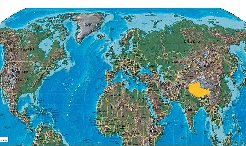
Tibet On A World Map
Tibet Map And Its Neighboring Countries
One of the easiest ways to understand Tibet’s geographical position is to place it alongside its southern neighbors.
Tibet shares international borders with:
- Nepal to the southwest
- India along the southern and southwestern areas
- Bhutan to the southeast
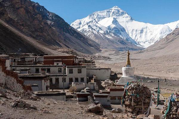
The Himalayas dominate much of this southern frontier. Mount Everest, for example, stands directly on the international boundary between Nepal and the Tibet Autonomous Region of China, making it one of the most recognizable geographical features on any map of Tibet.
This border location has also influenced travel routes for centuries. Tibet was connected with surrounding regions through trading routes, pilgrimage routes, and cultural exchanges long before modern highways and airports were built.
For international visitors today, the relationship between Tibet and its neighboring countries is particularly visible along the route between Lhasa and Kathmandu. The China–Nepal Friendship Highway crosses some of the most spectacular landscapes in Tibet, passing through high mountain passes, turquoise lakes, historic monasteries, and the Everest region before reaching the Nepal border.
A map makes it easier to understand why this route is so dramatic: travelers are moving across the southern edge of the Tibetan Plateau while the Himalayas rise around them.
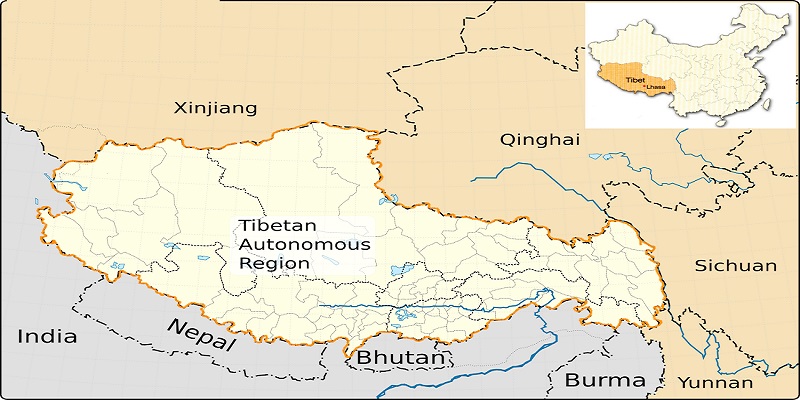
Map of Tibet and Surrounding Countries
Tibet Map Within China
A China map provides another important perspective. Tibet is located in southwestern China and shares internal borders with four major provincial-level regions:
- Xinjiang to the northwest
- Qinghai to the north
- Sichuan to the east
- Yunnan to the southeast
This positioning is important for understanding overland travel. Tibet is not an isolated destination accessible only by air. Several major highways connect it with neighboring parts of China, while the Qinghai–Tibet Railway provides a spectacular rail connection from Xining to Lhasa.
The eastern edge of Tibet is particularly interesting geographically. Around Nyingchi and Chamdo, the landscape gradually transitions from the broad, high Tibetan Plateau toward the complex mountain systems of the Hengduan Mountains. Deep valleys, forests, rivers, and lower elevations create a very different environment from the open grasslands of northern Tibet or the arid landscapes of Ngari.
This is why a detailed Tibet map is so useful for trip planning. Two destinations that appear relatively close on a small-scale map may offer completely different climates, landscapes, and travel experiences.
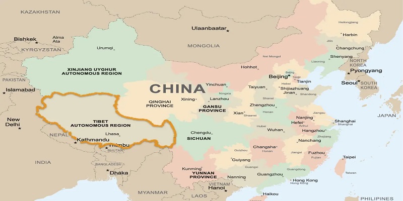
Map of Tibet in China
Tibet Map: The Main Administrative Areas
The Tibet Autonomous Region is divided into six prefecture-level administrative areas, together with Lhasa as the regional capital:
- Lhasa
- Shigatse
- Shannan
- Nyingchi
- Nagqu
- Chamdo
- Ngari
Each area has a distinct geographical identity.
Lhasa
Lhasa is the political, cultural, and transportation center of Tibet. Located at an elevation of approximately 3,650 meters, it is where many international travelers begin their Tibet journey.
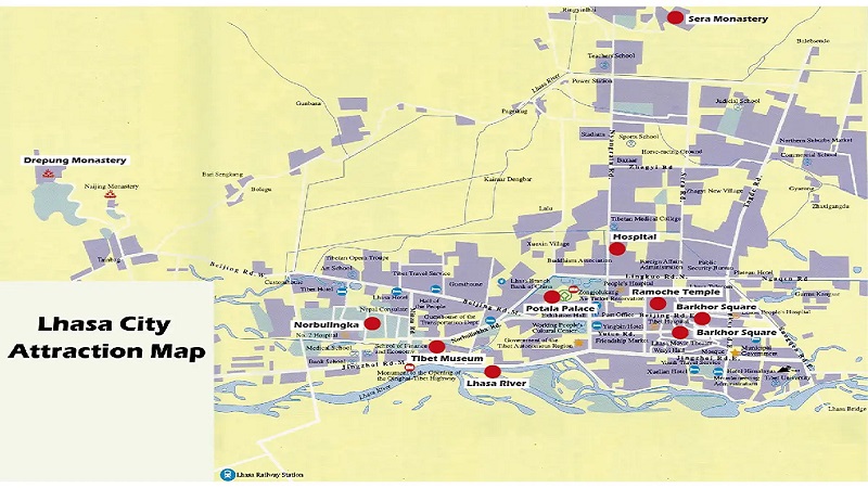
A Lhasa map usually highlights the Potala Palace, Jokhang Temple, Barkhor Square, Sera Monastery, Drepung Monastery, and Norbulingka. The city is also an important acclimatization base before traveling to higher destinations.
Shigatse
Shigatse lies west of Lhasa and is one of the most important destinations on the route toward Mount Everest. Tashilhunpo Monastery is one of its major attractions.
On a Tibet road map, Shigatse is also an important junction for journeys toward Everest, Nepal, and western Tibet.
Shannan
Shannan lies south of Lhasa and is closely associated with some of the earliest centers of Tibetan civilization. The region includes important cultural sites such as Samye Monastery and spectacular landscapes around the Yarlung Tsangpo River.
Nyingchi
Nyingchi occupies southeastern Tibet and is one of the region’s most visually distinctive areas. Compared with much of the high plateau, it has lower elevations, extensive forests, deep valleys, and a relatively mild climate.
Basong Tso, the Niyang River Valley, Lulang, and the Yarlung Tsangpo Grand Canyon are among the destinations that make Nyingchi especially attractive.
Nagqu
Northern Tibet is dominated by the vast Changthang region, with enormous grasslands, high-altitude lakes, and remote pastoral landscapes. Nagqu is one of the best areas to understand the scale of the Tibetan Plateau.
Ngari
Ngari occupies much of western Tibet and is among the most remote parts of the region. Its landscape includes high-altitude deserts, enormous lakes, dramatic mountains, and some of Tibet’s most important pilgrimage destinations.
Mount Kailash and Lake Manasarovar are the most famous attractions in this part of Tibet.
Chamdo
Chamdo lies in eastern Tibet, where the landscape becomes increasingly mountainous and deeply carved by rivers and valleys. Its location makes it an important geographical transition zone between the Tibetan Plateau and the Hengduan Mountains.
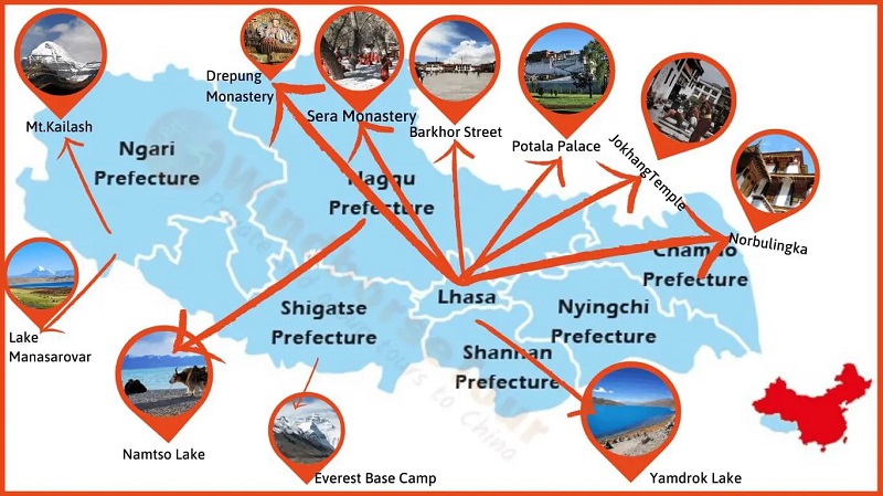
Tourist Map of Tibet
The Greater Tibetan Cultural Region Map
A map of Tibet can sometimes be misleading if it only displays the modern administrative boundary of the Tibet Autonomous Region.
The broader Tibetan cultural area extends beyond the TAR into parts of Qinghai, Sichuan, Gansu, and Yunnan. These areas are often associated with the three traditional cultural regions of Tibet: U-Tsang, Amdo, and Kham.
Each has developed distinctive local traditions, dialects, landscapes, and cultural characteristics.
U-Tsang is closely associated with central and western Tibet, including Lhasa and Shigatse. Amdo extends across parts of the northeastern Tibetan Plateau, while Kham is associated with eastern Tibetan cultural areas, including parts of Sichuan, Yunnan, Qinghai, and eastern Tibet.
For travelers researching Tibet, understanding this broader map explains why Tibetan culture can be encountered far beyond the boundaries shown on a standard political map of the Tibet Autonomous Region.
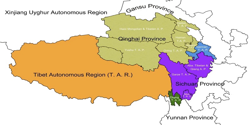
Map of Greater Tibetan Area in China
Physical Map Of Tibet: Mountains, Plateaus, And Valleys
A physical Tibet map tells an even more impressive story.
The Tibetan Plateau is the world’s highest major plateau, with an average elevation generally exceeding 4,000 meters. Its landscape is not simply a flat highland. It contains enormous mountain ranges, glaciers, valleys, grasslands, deserts, wetlands, and hundreds of lakes.
The geography changes considerably from north to south and from east to west.
In northern Tibet, the Changthang Plateau dominates the landscape. Vast grasslands and high-altitude basins stretch toward the horizon, supporting traditional pastoral lifestyles.
In southern Tibet, river valleys provide relatively favorable conditions for settlement and agriculture. The Yarlung Tsangpo valley is particularly important, with highland barley forming an important agricultural crop.
In western Tibet, the landscape becomes increasingly dry and remote. Ngari is characterized by high-altitude deserts, salt lakes, barren mountains, and sacred pilgrimage sites.
Along the southern edge, the Himalayas create a spectacular chain of snow-covered peaks and glaciers, including Mount Everest.
In eastern and southeastern Tibet, deep gorges, dense forests, and steep mountain ranges create an environment that looks dramatically different from the open plateau.
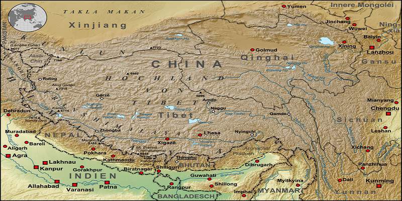
Physical Map of the Tibetan Plateau
Tibet Map And The Rivers Of Asia
Tibet is sometimes described as the “water tower of Asia,” and a river map explains why.
The Tibetan Plateau is the source area for several major river systems that flow through China and neighboring Asian countries.
The Yangtze River begins in the Tanggula Mountains and eventually travels eastward across China.
The Yarlung Tsangpo River originates in western Tibet and travels east across the plateau before entering a spectacular gorge. After leaving Tibet, it becomes the Brahmaputra River in India.
The Mekong River originates on the Tibetan Plateau before flowing through mainland Southeast Asia.
The Salween River also begins in the highlands and flows through Tibet and Yunnan before continuing into Myanmar.
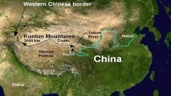
The Yellow River originates on the northeastern part of the Tibetan Plateau in Qinghai.
When these rivers are plotted on a map, Tibet’s environmental importance becomes clear. Water originating in the highlands eventually supports ecosystems, agriculture, and communities across a huge portion of Asia.
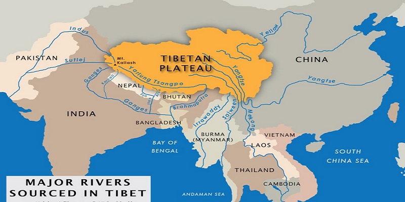
Map of The Tibetan Plateau River
Satellite Map Of Tibet: Seeing The Roof Of The World
Satellite imagery provides perhaps the clearest visual representation of Tibet’s enormous scale.
From space, the Tibetan Plateau appears as a vast elevated landmass surrounded by mountain ranges. Snow-covered Himalayan peaks stand out along the southern edge, while glaciers, river valleys, lakes, and desert-like landscapes can be identified across the plateau.
Satellite maps are particularly useful for understanding why Tibet is often called the Roof of the World. The name is not simply a reference to Mount Everest. It reflects the extraordinary elevation and geographical scale of the entire plateau.
For travelers, satellite imagery can also help explain why journeys that look simple on a conventional map may take many hours or even several days by road. Mountain passes, enormous distances, and high-altitude terrain have a major effect on travel times.
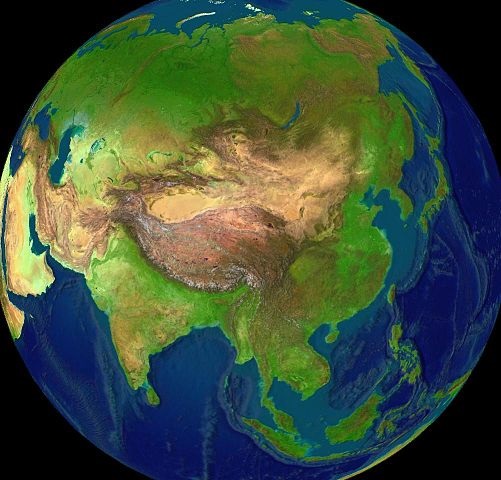
Map of The Tibetan Plateau River
Tibet Transportation Map: How To Reach Tibet
A transportation map is one of the most useful maps to consult before planning a Tibet trip.
International travelers generally enter Tibet through mainland China or, depending on their itinerary and applicable arrangements, through Nepal. Lhasa is the principal gateway for most journeys.
Flights To Tibet
Lhasa Gonggar Airport is the main aviation hub. Flights connect Lhasa with major cities in China, including Chengdu, Beijing, Xi’an, Chongqing, and Kunming.
There is also an international air connection between Lhasa and Kathmandu.
Other airports serve different parts of Tibet, making air travel useful for reaching destinations such as Nyingchi and Ngari.
Road Map Of Tibet
Tibet’s major highways connect it with Sichuan, Yunnan, Qinghai, Xinjiang, and Nepal.
For international tourists, overland journeys are often among the highlights of a Tibet trip because the route itself becomes part of the experience. A journey from Lhasa toward Everest, for example, can include turquoise lakes, high mountain passes, monasteries, grasslands, and Himalayan viewpoints.
The China–Nepal Friendship Highway is particularly famous. It connects Lhasa with the Nepal border and provides access to destinations including Shigatse and Mount Everest.
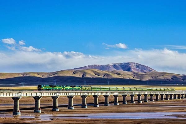
Qinghai–Tibet Railway Map
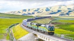
The Qinghai–Tibet Railway connects Xining with Lhasa and crosses some of the highest railway terrain in the world.
The journey passes through vast plateau landscapes, mountain ranges, grasslands, and high-altitude areas around places such as Golmud and Nagqu.
For travelers concerned about adjusting to Tibet’s elevation, the train journey can also be an attractive way to experience the gradual transition into the plateau, although individual responses to altitude vary.
Tibet Tourist Map: Where Are The Main Attractions?
Once you understand Tibet’s geography, the major attractions become much easier to organize.
A typical first-time itinerary often centers on Lhasa, where travelers visit the Potala Palace, Jokhang Temple, Barkhor Square, Sera Monastery, Drepung Monastery, and Norbulingka.
Around Lhasa, popular excursions include Yamdrok Lake, Namtso Lake, Ganden Monastery, and Samye Monastery.
Further west, the route toward Shigatse and Mount Everest introduces travelers to high Himalayan landscapes and the northern face of Everest.
In southeastern Tibet, Nyingchi, Basong Tso, Lulang, and the Yarlung Tsangpo Grand Canyon offer forests, rivers, deep valleys, and spectacular mountain scenery.
Farther west, Mount Kailash, Lake Manasarovar, and the ruins of the ancient Guge Kingdom form the heart of a very different Tibet characterized by remote landscapes and profound religious significance.
Tourist Map of Tibet
China–Nepal Friendship Highway Map
For travelers who want to understand Tibet geographically, the China–Nepal Friendship Highway is more than a line connecting two points.
Starting from Lhasa, travelers can travel west toward Shigatse and then continue toward the Himalayas. Important destinations along the way include Yamdrok Lake, Tashilhunpo Monastery, Sakya Monastery, and Mount Everest.
The route illustrates the extraordinary geographical transition from the cultural heart of central Tibet to the high Himalayan frontier.
Mount Everest Base Camp on the Tibetan side is particularly significant because it provides travelers with access to the northern face of the world’s highest mountain without requiring a technical climbing expedition.
Lhasa Map: The Starting Point For Many Travelers
A detailed Lhasa map is especially useful because many of the city’s most important attractions are concentrated in a relatively compact area.
The Potala Palace dominates the city’s skyline and is one of Tibet’s most recognizable landmarks.
Nearby, Jokhang Temple and Barkhor Square form the spiritual center of old Lhasa. Pilgrims, local residents, and visitors gather around the temple, while traditional streets surround the historic core.
The major monastic institutions of Sera and Drepung provide another perspective on Tibetan Buddhist culture.
Norbulingka, traditionally associated with the Dalai Lama’s summer residence, provides a quieter environment with gardens, historic buildings, and seasonal vegetation.
A city map therefore helps visitors organize their first few days efficiently while leaving time to adjust to the altitude.
Lhasa City Map
Tibet Trekking Map: Major Hiking Routes
Tibet’s geography creates exceptional opportunities for trekking, although the altitude means that these journeys require careful planning.
The Ganden to Samye Trek is one of the classic routes near Lhasa. The multi-day journey crosses alpine landscapes and high passes while connecting two important religious sites.
The Mount Kailash Kora is among the world’s most famous pilgrimage treks. The approximately 52-kilometer circuit passes through Darchen, Dirapuk, and Dzutrulpuk, with the route reaching the high Drolma La Pass at around 5,630 meters.
The Everest Base Camp trek from the Tibetan side offers another legendary experience. The route can begin around Old Tingri and continue toward Rongbuk Monastery and the northern face of Everest.
Unlike conventional city sightseeing, these routes require travelers to think about elevation, weather, road conditions, accommodation, and acclimatization as much as distance.
Tibet On Google Maps
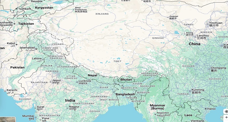
International travelers often use digital maps to research Tibet before departure. Major cities such as Lhasa and Shigatse are easy to identify, while major roads, attractions, and geographical features can be explored through mapping applications.
However, remote areas may contain less detailed mapping information than major urban destinations. For complicated multi-day journeys, a professional itinerary and local transportation arrangements remain important.
A useful approach is to combine several types of maps: a political map to understand administrative boundaries, a physical map to understand terrain, a transportation map to plan routes, and a tourist map to locate attractions.
Together, these maps provide a much more complete picture of Tibet.
Tibet on Google Maps
Tibet Map FAQs
Where Is Tibet Located?
Tibet is located in southwestern China on the Tibetan Plateau. It borders Nepal, India, and Bhutan to the south and shares internal borders with Xinjiang, Qinghai, Sichuan, and Yunnan.
Is Tibet Part Of China?
Yes. The Tibet Autonomous Region is an administrative region of the People’s Republic of China and was formally established in 1965.
What Is The Average Elevation Of Tibet?
The Tibetan Plateau generally has an average elevation of more than 4,000 meters above sea level, making it the highest major plateau on Earth.
Why Is Tibet Called The Roof Of The World?
Tibet is known as the Roof of the World because of its exceptional elevation, enormous plateau, and surrounding mountain systems, including the Himalayas and Mount Everest.
What Countries Border Tibet?
The Tibet Autonomous Region borders Nepal, India, and Bhutan along its southern and southwestern sides.
What Are The Most Important Places On A Tibet Tourist Map?
For a first visit, major locations include Lhasa, Shigatse, Nyingchi, Yamdrok Lake, Namtso, Mount Everest, Mount Kailash, and Lake Manasarovar.
Planning A Tibet Journey With Tibet Yulong
A map is only the beginning of understanding Tibet. The real challenge is turning its enormous geography into a practical itinerary that matches your interests, travel time, altitude tolerance, and preferred transportation.
For international travelers, Tibet Yulong can help organize local travel arrangements, transportation, accommodation, permits, guides, and customized Tibet itineraries. This is particularly useful for journeys to remote areas such as Mount Everest, Mount Kailash, Ngari, and eastern Tibet, where distances are substantial and travel logistics are more complicated than they appear on a standard map.
Whether you want to explore Lhasa’s historic center, follow the China–Nepal Friendship Highway to Everest, discover the forests of Nyingchi, travel across the vast northern plateau, or undertake a pilgrimage around Mount Kailash, studying a Tibet map first will give you a much clearer understanding of the journey ahead. Tibet is enormous, but once its geography is understood, its seemingly distant destinations begin to form a fascinating and connected story of mountains, rivers, cultures, and ancient travel routes.