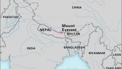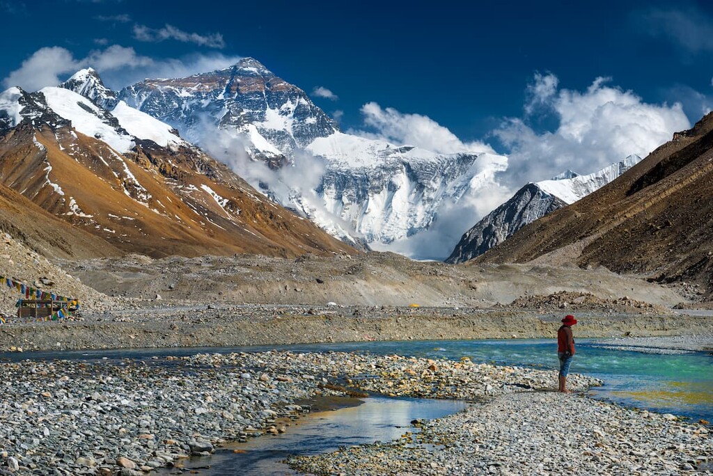

Mount Everest is more than the highest mountain on Earth – it is a landmark that sits directly on the international border between Nepal and China’s Tibet Autonomous Region. If you look at a Mount Everest map, the summit appears on the crest of the Mahalangur Himal range, separating Nepal’s Solukhumbu District from Tingri County in Tibet. Its location explains why Everest can be approached from two very different sides, each with its own landscapes, climbing routes, base camps, cultures, and travel experiences. Whether you are planning an Everest Base Camp trek, a Tibet tour, or simply trying to understand where Mount Everest is located, knowing how to read the mountain on a map is the best place to start.
Key Points At A Glance
- Location: On the Nepal–China border in the Himalayas.
- Coordinates: Approximately 27.9881° N, 86.9250° E.
- Official elevation: 8,848.86 m (29,031.7 ft).
- Nepal side: Solukhumbu District, within Sagarmatha National Park.
- Tibet side: Tingri County, Xigazê Prefecture, Tibet Autonomous Region.
- Main climbing routes: South Col Route from Nepal and North Face/Northeast Ridge Route from Tibet.
- Best viewing and climbing seasons: Generally spring and autumn, although the ideal period depends on whether you are trekking, sightseeing, or attempting a summit.
- Major access points: Kathmandu and Lukla on the Nepal side; Lhasa and Shigatse on the Tibet side.
Where Is Mount Everest On The Map?
If you open a world map and search for the Himalayas, Mount Everest is located in southern Asia, along the enormous mountain arc that separates the Indian subcontinent from the Tibetan Plateau. It stands close to the northern edge of Nepal and the southern edge of Tibet, China.
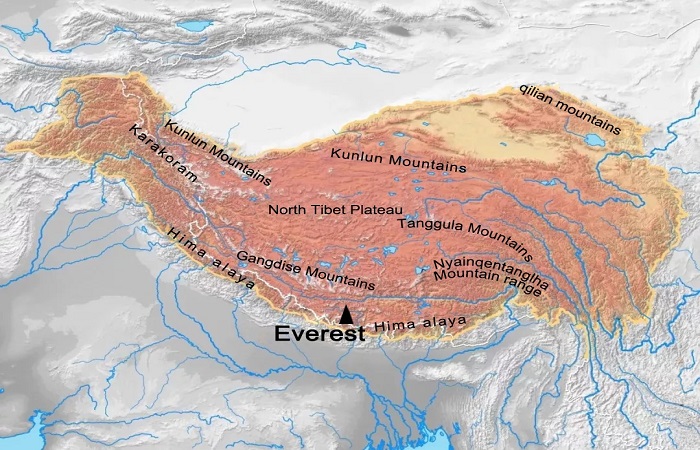
More precisely, Mount Everest is situated on the crest of the Mahalangur Himal sub-range of the Himalayas. The mountain forms part of a dramatic concentration of some of the world’s highest peaks, including Lhotse, Nuptse, and several other major Himalayan summits.
The summit itself lies directly on the international boundary between Nepal and China. This is an important detail when looking at a Mount Everest map because Everest is not simply a mountain located entirely inside one country. Its position on the border gives it two geographical faces: the southern side in Nepal and the northern side in Tibet.
On the Nepalese side, Everest is associated with Solukhumbu District in Koshi Province and the famous Sagarmatha National Park. On the Chinese side, the mountain is located in Tingri County, within Xigazê Prefecture of the Tibet Autonomous Region.
This border location also explains why travelers can experience Everest in dramatically different ways. A journey from Nepal generally approaches the mountain through the Khumbu Valley, while a journey from Tibet crosses the Tibetan Plateau before reaching the northern Everest Base Camp.
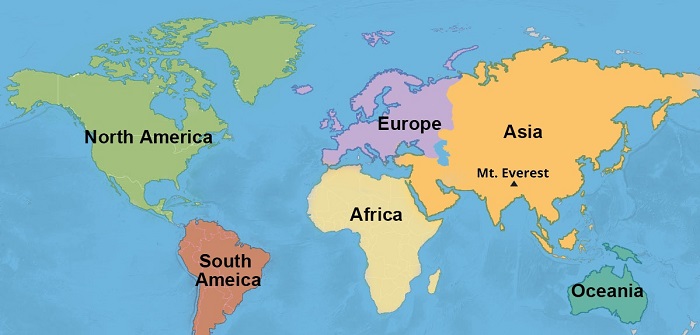
Mount Everest on World Map
Mount Everest Coordinates: How To Find It On A Map
One of the easiest ways to locate Everest digitally is by using its geographic coordinates.
The coordinates commonly used for Mount Everest are approximately 27.9881° N latitude and 86.9250° E longitude. Another commonly displayed coordinate is 27.9882° N, 86.9254° E. Slight differences can appear depending on the mapping system and reference point being used.
You can enter the coordinates directly into a digital mapping application such as Google Maps, OpenStreetMap, a GPS device, or geographic information software.
Simply enter: 27.9881, 86.9250. The map should take you directly toward the Everest summit area. When you zoom out, you can see the mountain’s position in relation to Nepal, Tibet, the Himalayan range, and neighboring peaks.
Coordinates are especially useful because place names can vary between languages and mapping systems. A search for “Mount Everest,” “Everest,” “Sagarmatha,” or “Chomolungma” may produce slightly different map labels, but geographic coordinates provide a much more direct way to identify the mountain.
For travelers planning an Everest trip, however, finding the summit on a digital map is only the beginning. The actual travel routes to Everest Base Camp are considerably more complicated because the mountain is located in one of the highest and most rugged environments on Earth.
Which Countries Share Mount Everest?
Mount Everest is shared geographically by Nepal and China, with the summit positioned on their international boundary.
On the Nepal side, Everest is located in the Solukhumbu District of Koshi Province. The surrounding region forms part of Sagarmatha National Park, an internationally recognized Himalayan protected area.
On the northern side, Everest lies in Tingri County of Xigazê Prefecture in Tibet, China.
This creates a fascinating situation: the world’s highest mountain has two principal approaches, two base-camp systems, and two very different travel experiences. The distinction is important for travelers because visiting Everest from Nepal and visiting Everest from Tibet are not simply two versions of the same journey.
From Nepal, travelers commonly fly from Kathmandu to Lukla and trek through the Khumbu Valley before reaching Everest Base Camp. The journey itself is a major part of the experience, with Sherpa villages, Buddhist monasteries, suspension bridges, forests, and high mountain valleys.
From Tibet, travelers can travel overland from Lhasa through Shigatse and Tingri toward the northern Everest Base Camp. Much of the journey is by road, allowing visitors to experience the vast Tibetan Plateau before reaching the foot of the world’s highest mountain.
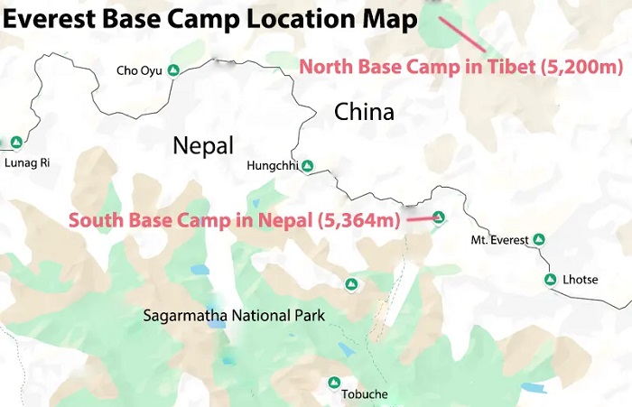
Map of Mount Everest Base Camp Location in Tibet and Nepal
Mount Everest On A Political Map
A political map is useful when your main question is simply, “Where is Mount Everest?”
On this type of map, you can clearly see the international boundary between Nepal and China and understand which administrative regions are associated with the mountain.
The key locations are:
| Side | Administrative Area | Major Access |
|---|---|---|
| Nepal | Solukhumbu District, Koshi Province | Kathmandu → Lukla |
| Tibet, China | Tingri County, Xigazê Prefecture | Lhasa → Shigatse → Tingri |
Political maps are particularly useful for understanding why travel regulations differ between the two sides. Nepal and China have separate tourism systems, permits, transportation arrangements, and regulations for accessing the Everest region.
For international travelers, this is one reason an Everest journey should be planned according to the specific side of the mountain you intend to visit.
Mount Everest On A Topographic Map
A topographic map tells a very different story.
Instead of simply showing countries and cities, a topographic Mount Everest map illustrates elevation, ridges, glaciers, valleys, passes, and climbing routes. For mountaineers, this type of map is far more useful than a conventional political map.
Everest rises from an enormous high-altitude landscape surrounded by other giant Himalayan peaks. The terrain is not a single smooth pyramid. It contains glaciers, ridges, steep faces, cols, rock bands, and complex valleys.
Two major climbing systems dominate maps of the mountain. The South Col Route approaches Everest from Nepal. The North Face or Northeast Ridge Route approaches Everest from Tibet.
Although both routes eventually reach the same summit, their geography is remarkably different.
Mount Everest South Route On The Map
The southern approach begins in Nepal and leads toward Everest through the Khumbu region.
For most trekkers, the journey begins at Lukla, where travelers enter the high mountain environment before following trails through the Khumbu Valley. Important places on a map include Lukla, Phakding, Namche Bazaar, Tengboche, Dingboche, and eventually Everest Base Camp.
Everest Base Camp on the Nepal side is located at approximately 5,364 meters (17,598 feet). From the base camp, the climbing route continues through the Khumbu Icefall toward the Western Cwm and eventually the South Col. The South Col is the high mountain pass between Everest and Lhotse.
A simplified map sequence looks like this:
Lukla → Namche Bazaar → Tengboche → Dingboche → Everest Base Camp → Khumbu Icefall → Western Cwm → Lhotse Face → South Col → Summit
The South Route is famous not only because it leads to Everest but also because the approach itself has become one of the world’s classic trekking journeys.
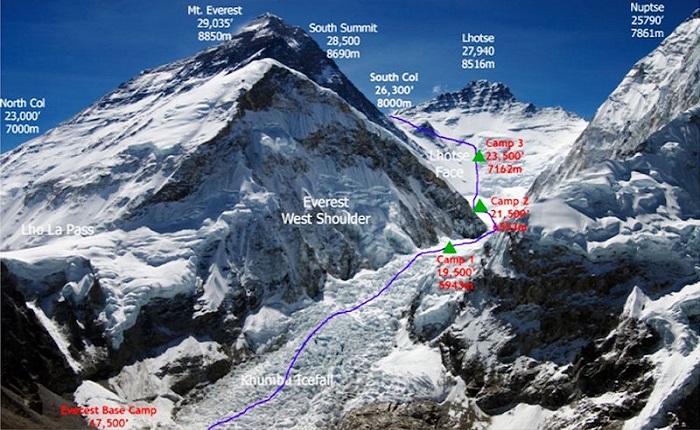
Mt. Everest South Col Route
Mount Everest North Route On The Map
The northern route begins in Tibet and provides a completely different geographical perspective. Instead of trekking for days through the Khumbu Valley, travelers can approach Everest from the Tibetan Plateau. The journey commonly passes through Lhasa, Shigatse, and Tingri before reaching the northern Everest Base Camp area.
The Tibetan side is particularly notable for its enormous open landscapes. Rather than being surrounded immediately by the narrow valleys and forests characteristic of the Nepal approach, travelers cross broad high-altitude plateaus with enormous views toward the Himalayan range.
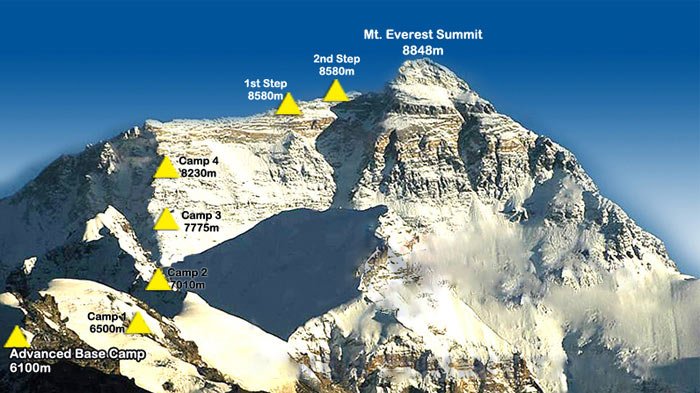
The northern climbing route begins around Rongbuk Glacier and continues toward the North Col and the Northeast Ridge.
A simplified route can be represented as:
Lhasa → Shigatse → Tingri → Everest Base Camp → Rongbuk Glacier → North Col → North Ridge → Summit
This geographical difference is one of the most important things to understand when looking at an Everest map. The mountain itself is the same, but the journey to it feels like two completely different Himalayan adventures.
Northeast Ridge Route
Mount Everest Height And Elevation On Maps
Modern maps generally identify Mount Everest as 8,848.86 meters (29,031.7 feet) above sea level. This is the official elevation jointly announced by Nepal and China in December 2020. Older maps and reference materials often show Everest as 8,848 meters. The newer figure reflects more advanced surveying and measurement techniques.
The difference may look small on paper, but at extreme altitude, every meter contributes to the extraordinary environment surrounding the summit. Everest is not simply the highest point in the Himalayas. It is the highest point above sea level on Earth, which is why maps of the world often use it as the ultimate reference point for mountain elevation.
When examining an Everest topographic map, however, the summit elevation is only one part of the story. The surrounding terrain is also extremely high. Base camps, glaciers, mountain passes, and neighboring peaks are already located at elevations where the human body must adapt carefully.
What Mountains Are Near Mount Everest?
Mount Everest does not stand alone.
The mountain is part of a spectacular cluster of Himalayan peaks, and a detailed Everest map reveals how closely several major mountains are positioned around it.
Lhotse is immediately adjacent to Everest and rises to more than 8,500 meters. The South Col lies between Everest and Lhotse.
Nuptse is another major peak near the Nepalese approach and forms an important part of the dramatic mountain skyline seen from the Khumbu region.
On the northern side, the Rongbuk Glacier provides one of the classic geographical approaches toward Everest. The North Face rises dramatically above the surrounding Tibetan landscape.
This concentration of giant peaks is one reason the Everest region is so visually impressive. Travelers do not simply travel to see one mountain; they enter an entire landscape dominated by enormous Himalayan summits.
Mount Everest Himalayas Map
Mount Everest Glaciers: Khumbu And Rongbuk
Glaciers are among the most important geographical features to look for on an Everest map.
On the Nepal side, the Khumbu Glacier is closely associated with the South Col climbing route. Its upper section forms the notorious Khumbu Icefall, one of the most technically challenging and dynamic sections of the southern route. The glacier is constantly changing because the ice moves and fractures at high altitude. This creates crevasses, ice towers, and other hazards.
On the Tibet side, the Rongbuk Glacier provides the geographical approach toward the North Face of Everest.
The Rongbuk Valley and glacier also offer some of the most spectacular views of Everest available to ordinary travelers. Visitors approaching from Tibet can see the mountain rising dramatically above the northern landscape.
For this reason, a satellite or terrain map can be especially valuable when planning an Everest journey. It shows features that are impossible to understand from a simple political map.
Everest Base Camps On A Map
One of the most common sources of confusion is the existence of two Everest Base Camps.
There is an Everest Base Camp in Nepal and an Everest Base Camp in Tibet. They are not located on opposite sides of the same small valley. They are separate approaches to the same mountain.
The Nepal Base Camp is approximately 5,364 meters above sea level and is reached through the Khumbu trekking route.
The Tibetan Base Camp is located on the northern side of Everest and can be reached by road from the Tibetan Plateau.
The two locations also offer very different views.
From the Nepal side, trekkers experience Everest within a dramatic collection of surrounding peaks and glaciers. The journey through the Khumbu Valley is itself a major attraction.
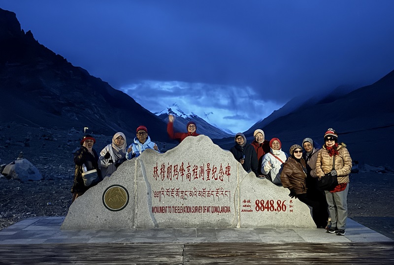
From the Tibetan side, the northern approach offers a particularly direct and expansive view of Everest. The mountain rises prominently above the open plateau and Rongbuk area.
For travelers who want to see Mount Everest without climbing it, the Tibetan side can be particularly attractive because the road-accessible approach allows visitors to reach the Everest Base Camp area without undertaking the long Nepal-side trek.
Mount Everest
How Far Is Mount Everest From Kathmandu And Lhasa?
Mount Everest is relatively close to major Himalayan gateway cities in straight-line distance, but the actual travel distance is much longer because of the terrain.
Kathmandu, the capital of Nepal, is approximately 160 kilometers (100 miles) southwest of Everest in a straight-line sense. However, reaching the mountain from Kathmandu requires a combination of air travel and trekking or other transportation. Most traditional Nepal-side trekkers travel from Kathmandu to Lukla and then continue on foot toward Everest Base Camp.
On the Tibetan side, Lhasa is the major gateway for international travelers. The journey from Lhasa to Everest takes travelers across the Tibetan Plateau, generally passing through Shigatse and Tingri before reaching the Everest region.
This is one of the major advantages of looking at a regional map rather than only a world map. A world map tells you where Everest is, but a regional map helps you understand how the mountain can actually be reached.
Best Places To Visit Around Mount Everest
Not everyone who visits the Everest region intends to climb the mountain. In fact, the majority of visitors come for trekking, sightseeing, photography, cultural experiences, or simply the opportunity to stand near the highest mountain on Earth.
Everest Base Camp
Everest Base Camp is the most famous destination in the region. On the Nepal side, reaching it requires a multi-day trek through the Khumbu Valley. On the Tibetan side, the northern base camp can be accessed by road as part of a guided Tibet journey.
Namche Bazaar
Namche Bazaar is one of the most important settlements on the Nepal-side Everest trekking route. Located at approximately 3,440 meters, it is both a cultural center and an important acclimatization point.
Its location on the map helps explain why it became such an important Himalayan trading and trekking hub.
Tengboche Monastery
Tengboche Monastery stands at approximately 3,867 meters and is one of the most important Buddhist sites in the Khumbu region. Its elevated location provides spectacular views toward Everest, Ama Dablam, and Lhotse.
Gokyo Lakes
The Gokyo Lakes provide an alternative experience within the Everest region. Their glacial waters, surrounding mountains, and high-altitude landscapes make them particularly popular with photographers and trekkers.
Kala Patthar
At approximately 5,545 meters, Kala Patthar is famous for its panoramic views of Everest. Sunrise from this viewpoint is one of the most iconic experiences available to trekkers on the Nepal side.
Dingboche
Dingboche is another important acclimatization village in the Khumbu region. Its position provides spectacular views of surrounding Himalayan peaks while offering trekkers a place to rest before continuing higher.
Lukla And Phakding
Lukla and Phakding form important gateway points for the traditional Nepal-side Everest trek. They represent the transition from lower Himalayan environments into the high-altitude Khumbu region.
What Can You See Beyond Everest?
A Mount Everest map reveals that an Everest journey is not only about the summit.
On the Nepal side, travelers encounter Sherpa communities, Buddhist monasteries, suspension bridges, forests, glaciers, high mountain villages, and protected Himalayan ecosystems.
Sagarmatha National Park is home to diverse Himalayan wildlife, including Himalayan tahr, musk deer, red pandas, snow leopards, and numerous bird species.
Travelers can also experience traditional teahouse hospitality and local Buddhist culture.
Other popular activities include scenic mountain flights from Kathmandu, helicopter tours, trekking routes, visits to monasteries, and introductory climbing experiences on peaks such as Island Peak and Mera Peak.
These experiences demonstrate an important point: you do not need to climb Mount Everest to have an Everest adventure.
The Cultural Meaning Of Mount Everest
A map can show Everest’s coordinates, borders, elevation, glaciers, and routes, but it cannot fully explain what the mountain means to the people who live around it.
In Nepal, Everest is known as Sagarmatha. In Tibet, it is known as Chomolungma. These traditional names reflect the mountain’s deep cultural and spiritual significance.
For local communities, Everest is not simply a geographical object or an extreme climbing challenge. It forms part of a sacred Himalayan landscape connected to religious traditions, local livelihoods, and generations of cultural history.
This is particularly important for international travelers. An Everest journey becomes much more meaningful when visitors look beyond the idea of “conquering the world’s highest mountain” and take time to understand the people, traditions, and environment surrounding it.
When Is The Best Time To Visit Mount Everest?
The location of Everest strongly influences its climate.
For travelers who want clear mountain views, spring and autumn are generally considered the most favorable periods. Spring, particularly April and May, is also associated with the main climbing season because weather conditions can provide a relatively favorable window for summit attempts.
Autumn, especially September and October, is another excellent period for sightseeing and trekking. After the summer monsoon, the atmosphere can become much clearer, producing exceptionally sharp views of the Himalayan peaks.
Winter is extremely cold at high elevations, while the summer monsoon can bring cloud, rain, and reduced visibility, particularly on the Nepal side.
The best month therefore depends on what you intend to do. A professional summit expedition, a multi-day trek, and a short Everest sightseeing trip do not necessarily require the same conditions.
Why The Everest Map Matters For Travelers
Understanding the geography of Everest before your journey can prevent a great deal of confusion.
If you search for “Everest Base Camp” without first understanding the mountain’s geography, you may assume there is one base camp. In reality, Nepal and Tibet provide two separate approaches.
If you search for Everest on a political map, you may see the summit directly on the Nepal–China border.
If you switch to a topographic map, you can see why the mountain is so difficult to climb.
If you use satellite imagery, you can identify glaciers, valleys, roads, base camps, and surrounding peaks.
And if you use coordinates, you can locate the summit precisely even when map labels differ.
For travelers, these different map perspectives turn an abstract destination into a journey that can actually be understood.
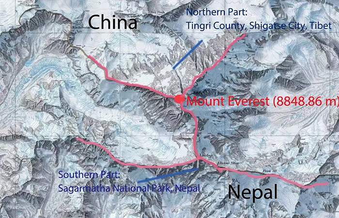
Mount Everest Location Map
Visiting Everest From The Tibetan Side
For international tourists who want to experience Everest without undertaking a technical climbing expedition, the Tibetan side offers a particularly distinctive way to approach the mountain.
A typical Tibet Everest journey can begin in Lhasa, where travelers have time to experience Tibetan culture and acclimatize before heading west toward Shigatse and the Everest region. The overland journey itself becomes part of the experience. Instead of spending most of the trip trekking toward Everest, travelers cross the enormous Tibetan Plateau and gradually approach the Himalayas. Eventually, the landscape changes from broad plateau to increasingly dramatic mountain terrain, culminating in views of Everest from the northern side.
Because international travelers visiting Tibet must follow specific travel and permit arrangements, planning through a qualified local travel agency is essential. Depending on the itinerary, travelers may need the appropriate Tibet Travel Permit and additional permits for areas such as Everest.
Planning Your Mount Everest Map Journey With Tibet Yulong
For international travelers who want to explore Mount Everest from Tibet, Tibet Yulong can help organize the journey from Lhasa to the Everest region, including transportation, accommodation, permits, local guides, and sightseeing arrangements.
The advantage of working with a Tibet-based travel agency is that the journey can be planned around more than simply reaching Everest Base Camp. Travelers can combine Everest with Lhasa, Shigatse, Tibetan monasteries, high mountain passes, sacred lakes, and other destinations across the Tibetan Plateau.
Whether your goal is to photograph Everest, visit the northern Base Camp, explore Tibet’s cultural heritage, or build a longer Himalayan adventure, understanding the mountain’s position on the map is the first step. Everest may be a single summit, but the landscapes, routes, cultures, and experiences surrounding it create an enormous world to explore.
Frequently Asked Questions About The Mount Everest Map
Where Is Mount Everest Located?
Mount Everest is located on the international border between Nepal and China, with the northern side in Tibet. Geographically, it stands in the Mahalangur Himal sub-range of the Himalayas.
What Are The Coordinates Of Mount Everest?
The commonly used coordinates are approximately 27.9881° N, 86.9250° E. Some mapping systems may display slightly different figures, such as 27.9882° N, 86.9254° E.
Which Country Is Mount Everest In?
The summit lies directly on the border between Nepal and China. Nepal controls the southern approach, while China’s Tibet Autonomous Region contains the northern approach.
What Is The Official Height Of Mount Everest?
The official elevation is 8,848.86 meters (29,031.7 feet) above sea level, based on the joint elevation announcement by Nepal and China in 2020.
Can I Find Mount Everest On Google Maps?
Yes. Entering 27.9881, 86.9250 into a mapping application should take you to the Everest summit area. You can then zoom out to understand its relationship with Nepal, Tibet, and the surrounding Himalayan peaks.
How Many Everest Base Camps Are There?
For tourism and climbing purposes, there are two principal Everest Base Camp areas: one on the Nepal side and another on the Tibet side. They provide different approaches and views of the same mountain.
Which Side Of Everest Is Better For Tourists?
There is no universal answer. The Nepal side is famous for its classic Everest trekking experience, Sherpa villages, and the Khumbu Valley. The Tibetan side offers a road-accessible northern approach, spectacular views from the plateau, and a different cultural and geographical experience.
What Is The Best Time To See Mount Everest?
Spring and autumn generally provide some of the clearest conditions. April and May are particularly important for climbing, while September and October are often excellent for sightseeing and trekking after the monsoon season.