
Mount Kailash is one of the most remote and sacred destinations on the Tibetan Plateau. Located in western Tibet’s Ngari Prefecture, the mountain rises dramatically above the surrounding landscape and is revered by several religious traditions. A map of Mount Kailash is especially useful for understanding not only where the mountain is located, but also how the Kailash Kora connects with Darchen, Lake Manasarovar, Mount Everest, Lhasa, and the Nepal border. This guide explains the location of Mount Kailash, the main pilgrimage route, and the most important travel routes for international visitors.
Key Takeaways
- Location: Ngari Prefecture, western Tibet, within the Gangdise (Kailash) mountain range.
- Elevation: Mount Kailash reaches approximately 6,638 meters (21,778 feet).
- Main pilgrimage route: The outer Kailash Kora begins and ends near Darchen.
- Kora distance: The outer circuit is roughly 52 km, normally completed in three days.
- Highest point: Drolma La Pass, at approximately 5,630 meters (18,471 feet).
- Main access routes: Travelers can reach Kailash from Lhasa or Kathmandu via Gyirong Port.
- Nearby highlights: Lake Manasarovar, Mount Everest, Peiku Tso, Shishapangma, and the ruins of the Guge Kingdom.
- Best travel periods: April–June and September–October are generally favorable periods for visiting western Tibet.
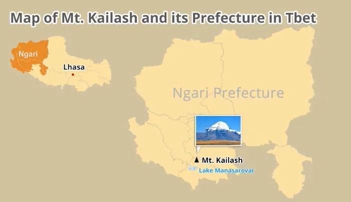
Where Is Mount Kailash On The Map?
Mount Kailash is located in western Tibet, in Ngari Prefecture, one of the most remote areas of the Tibet Autonomous Region. The mountain forms part of the Gangdise Mountains, also known internationally as the Kailash Range.
At approximately 6,638 meters above sea level, Kailash is not the highest mountain in Tibet, but its isolated position makes it one of the most visually distinctive. Unlike many Himalayan peaks that form part of large mountain groups, Mount Kailash rises prominently from the surrounding high plateau.
On a regional map, Kailash is positioned far west of Lhasa and relatively close to the borders of Nepal and India. Its remote location is an important part of the travel experience: reaching the mountain requires crossing enormous high-altitude landscapes rather than simply traveling from one major city to another.
The mountain is also surrounded by an extraordinary concentration of natural and religious landmarks. Lake Manasarovar lies nearby, while the ancient Guge Kingdom is located farther west. The wider region is characterized by high-altitude deserts, mountains, lakes, grasslands, and vast open valleys.
For international visitors, understanding the map is therefore more than a question of geography. It helps explain why a Mount Kailash journey usually takes considerably longer than a simple sightseeing trip.
Location Map of Mount Kailash
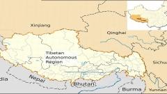
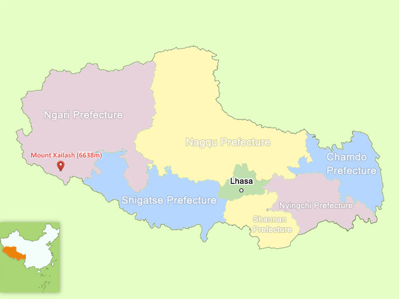
Mount Kailash On A Tibet Map
When looking at a map of Tibet, Mount Kailash is located toward the far western side of the region. Lhasa, the capital of Tibet, lies approximately 1,200 kilometers away, while Shigatse is roughly 950 kilometers away, according to the travel information provided for this route.
The journey between these destinations is not simply a matter of distance. Much of western Tibet lies at elevations above 4,000 meters, and travelers gradually cross mountain passes, plateaus, river valleys, and high-altitude settlements.
This geographical isolation is one reason Mount Kailash has retained such a strong sense of remoteness.
A typical map of western Tibet will show several important places around the mountain:
- Darchen, the main starting point for the Kailash Kora
- Lake Manasarovar, one of the region’s most important sacred lakes
- Lake Rakshastal, another major lake near Kailash
- Saga, an important stopping point on the journey
- Peiku Tso, a scenic high-altitude lake
- Shishapangma, one of the world’s highest mountains
- Mount Everest, farther south-east
- Ngari Prefecture, the wider administrative region
Together, these locations form the geographic framework of a Mount Kailash pilgrimage.
Mount Kailash On A Tibet Map
Mount Kailash Kora Map And Route
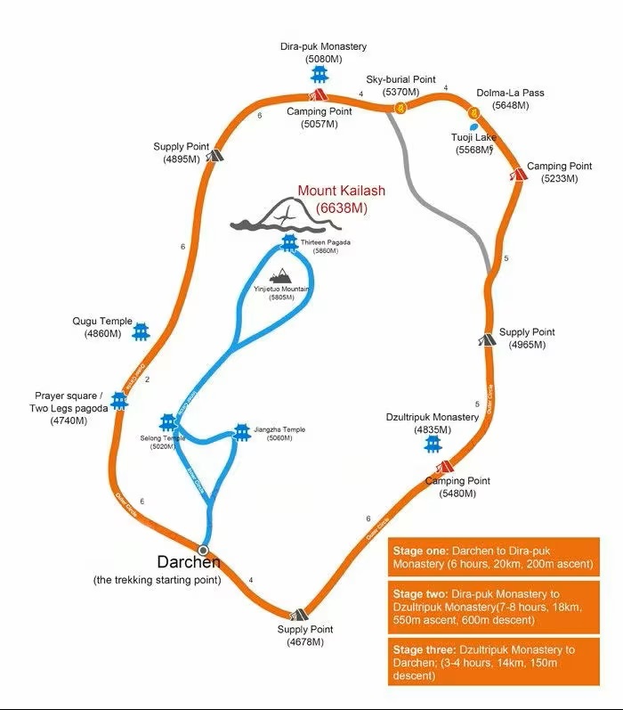
For most visitors, the most important map is not simply a location map but a Mount Kailash Kora map.
The Kora is the traditional circumambulation of the mountain. Rather than climbing Kailash, pilgrims and travelers walk around it, following a route through some of the most dramatic high-altitude terrain in western Tibet.
There are traditionally two pilgrimage circuits: the outer Kora and the inner Kora. The outer route is the standard circuit undertaken by most visitors.
The outer Kora begins and ends around Darchen, the settlement that serves as the main gateway to Mount Kailash. The complete route is approximately 52 kilometers and is usually divided into three days.
Day One: Darchen To Dirapuk
The first section connects Darchen with Dirapuk Monastery. The route covers approximately 20 kilometers and involves a gradual but sustained ascent.
For many travelers, this is the first day when the scale of Mount Kailash becomes fully apparent. The mountain remains a constant presence as the trail moves deeper into the valley.
The route generally takes around seven hours, depending on walking speed, altitude, weather, and rest stops.
Dirapuk is an important overnight location because it provides access to spectacular views of the mountain and prepares travelers for the much more demanding second day.
Although some experienced pilgrims may complete longer sections in a shorter period, international visitors should avoid treating the Kora as a race. At these elevations, maintaining a steady pace is much more important than maximizing walking speed.
Day Two: Dirapuk To Dzultripuk
The second day is generally considered the hardest part of the Kailash Kora.
The route from Dirapuk to Dzultripuk covers approximately 18 kilometers, but the distance alone does not explain the difficulty. The trail crosses Drolma La Pass, the highest point of the entire Kora at approximately 5,630 meters.
The ascent toward the pass is steep, and the thin air can make even relatively short climbs exhausting.
Weather can also change quickly. Strong winds and cold temperatures are possible, so travelers should be prepared for conditions that can feel very different from those in lower parts of Tibet.
After crossing Drolma La, the trail descends toward the Dzultripuk area. The descent can be demanding on the knees and legs, particularly after the steep climb.
For most visitors, this is the day when physical preparation and proper acclimatization matter most.
Day Three: Dzultripuk To Darchen
The final section is considerably easier.
The route from Dzultripuk back to Darchen is approximately 14 kilometers and mainly involves descending terrain. Depending on fitness and conditions, travelers may complete this section in roughly three to five hours.
Once back in Darchen, the three-day outer Kora is complete.
For many visitors, finishing the circuit is not simply the end of a trek. It is the culmination of a journey that combines physical endurance, dramatic landscapes, and the spiritual traditions surrounding Mount Kailash.
Map of Mount Kailash Kora
Map Of Lhasa To Mount Kailash
Lhasa is the most common starting point for international travelers entering Tibet from mainland China.
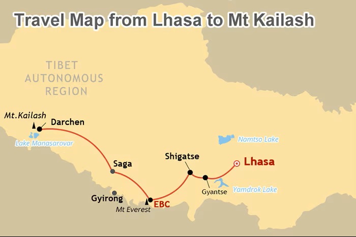
A typical Lhasa to Mount Kailash travel map shows a long overland journey through central and western Tibet. Rather than heading directly to Kailash, many itineraries incorporate some of the most important cultural and natural attractions along the way.
One common route passes through Gyantse and Shigatse before continuing westward.
Gyantse is known for its historic old town and important religious heritage. Shigatse, one of the major cities of Tibet, is home to Tashilhunpo Monastery, one of the region’s most significant monasteries.
From Shigatse, travelers continue toward the western plateau. Depending on the itinerary, the journey may include Mount Everest Base Camp, providing an opportunity to see the world’s highest mountain before continuing toward Kailash.
This makes a combined Everest and Kailash itinerary particularly attractive for international visitors who want to experience both of Tibet’s most iconic mountain destinations.
Map Of Lhasa To Mount Kailash
Lhasa To Mount Everest To Mount Kailash
A map connecting Lhasa, Mount Everest, and Mount Kailash reveals just how extensive this journey is.
After leaving Lhasa, travelers can visit places such as Yamdrok Lake, Gyantse, and Shigatse. From there, the route can continue toward Everest Base Camp.
The road toward Everest passes through high mountain terrain and mountain passes where travelers may see multiple Himalayan peaks. At Everest Base Camp on the Tibetan side, visitors can experience the dramatic north face of Everest before continuing west.
The journey then moves toward the Ngari region, with landscapes becoming increasingly remote and sparsely populated.
Among the major natural highlights on this section are Peiku Tso and Lake Manasarovar.
Eventually, travelers reach Darchen, the gateway to Mount Kailash.
This route is longer than traveling directly to one destination, but that is precisely what makes it appealing. The journey itself becomes part of the experience.
Map Of Kathmandu To Mount Kailash
Another major route to Mount Kailash begins in Kathmandu, Nepal.
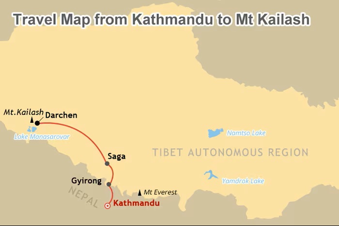
A Kathmandu-to-Kailash map follows a different geographic direction and crosses the Nepal–China border at Gyirong Port.
After traveling from Kathmandu toward the border, travelers enter Tibet and continue through Gyirong. The area is known for its deep valleys, mountains, vegetation, and relatively lower elevation compared with the high Tibetan plateau farther north.
Gyirong is therefore an important transition point.
From Gyirong, the route continues toward Saga, an important town on the way to western Tibet. From there, travelers continue across increasingly open high-altitude landscapes toward Darchen and Mount Kailash.
The road distance from Kathmandu to Mount Kailash is approximately 800 kilometers, although the actual travel experience depends on road conditions, border procedures, stops, and the itinerary.
The Kathmandu route is particularly appealing to travelers who want to combine Nepal and Tibet in one journey.
Map of Kathmandu to Mount Kailash
Major Attractions On The Mount Kailash Map
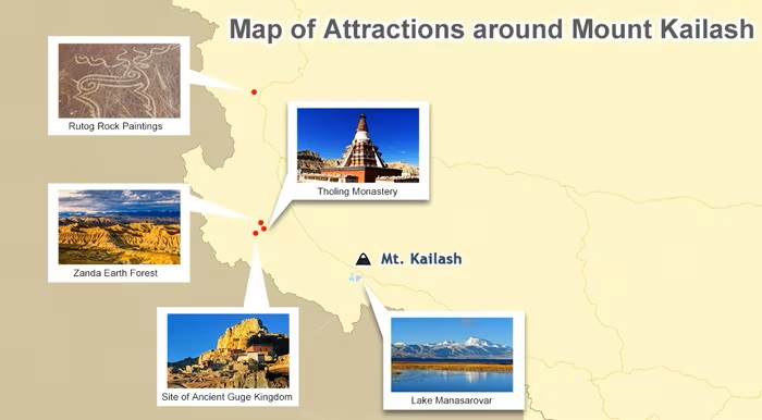
Mount Kailash is rarely visited as an isolated destination. A good regional map reveals numerous attractions that can be combined into one extended western Tibet journey.
Lake Manasarovar
Lake Manasarovar is one of the most important destinations near Mount Kailash. Its clear waters, immense scale, and religious significance make it an essential stop for many pilgrims.
The lake sits in a dramatic high-altitude environment surrounded by mountains and open plateau.
For travelers completing the Kailash Kora, visiting Lake Manasarovar provides a contrasting experience. The Kora is physically demanding, while the lakeside landscape encourages a slower and more contemplative experience.
Lake Rakshastal
Lake Rakshastal lies close to Lake Manasarovar and is another prominent geographical feature on maps of the Kailash region.
The two lakes create a remarkable landscape of contrasting colors and textures beneath the surrounding mountains.
Together with Kailash, they form one of the most recognizable geographic combinations in western Tibet.
Peiku Tso
Peiku Tso is an important high-altitude lake encountered on some routes between the Nepal border and the Kailash region.
The lake is surrounded by an expansive landscape with mountains rising in the distance. It is particularly impressive because of the sense of scale: there are few urban structures or dense settlements to interrupt the view.
Shishapangma
Shishapangma rises to 8,027 meters and is one of the world’s highest mountains.
Depending on the travel route, visitors may have an opportunity to see the mountain from the Tibetan plateau.
Its inclusion on a Mount Kailash travel map demonstrates how concentrated this region is with major Himalayan peaks.
Guge Kingdom
Farther west, the ruins of the ancient Guge Kingdom offer a completely different experience.
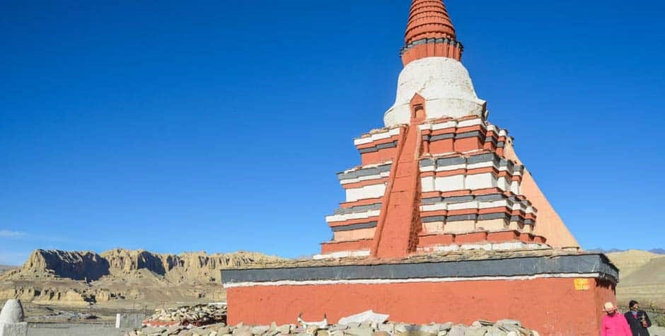
The former kingdom once flourished in western Tibet but eventually disappeared. Today, visitors can explore remnants of ancient settlements, palaces, caves, murals, and distinctive earth formations.
For travelers interested in history and archaeology, adding the Guge region to a Kailash itinerary can transform a mountain pilgrimage into a broader exploration of western Tibet.
Map of Attractions around Mount Kailash
Best Time To Visit Mount Kailash
The geography of Mount Kailash directly influences when travelers should visit.
Western Tibet has a cold, high-altitude climate, with significant differences between seasons and between daytime and nighttime temperatures.
The most commonly recommended periods for a Mount Kailash journey are April to June and September to October.
Spring can offer clear mountain scenery and increasingly favorable temperatures. Autumn is also attractive because the monsoon period has generally weakened and the weather can become more stable.
July and August are warmer, but they also correspond with the wetter part of the Tibetan travel season. Rainfall in the Kailash region is still relatively limited compared with many other parts of Asia, but travelers should be prepared for changing weather.
Winter is much colder and generally unsuitable for most international visitors planning a standard Kailash pilgrimage.
How A Mount Kailash Map Helps With Trip Planning
A good map allows travelers to understand the relationship between the destinations rather than viewing each attraction separately.
For example, a first-time visitor might initially think of Mount Kailash, Everest, and Lake Manasarovar as three independent attractions. On a regional map, however, their geographic relationship becomes much clearer.
You can use a Mount Kailash map to determine:
- Where Kailash is located in relation to Lhasa and Kathmandu
- How the Kora circles the mountain
- Where Darchen is situated
- How Lake Manasarovar fits into the landscape
- Which routes pass through Everest Base Camp
- Where the Nepal–Tibet border is located
- How long an overland itinerary may take
- Which attractions can reasonably be combined
For international travelers, this is especially useful because western Tibet is vast and journey times can be much longer than distances on a standard map might suggest.
Planning A Mount Kailash Journey With Tibet Yulong Travel
Because Mount Kailash is located in one of the most remote parts of Tibet, international travelers need to plan more carefully than they would for an ordinary sightseeing trip.
Travel arrangements, permits, transportation, accommodation, altitude acclimatization, and the Kora itinerary all need to be coordinated in advance.
Tibet Yulong Travel specializes in Tibet journeys for international visitors and can arrange Mount Kailash and Lake Manasarovar tours, including transportation, accommodation, permits, and the overland routes connecting Lhasa, Everest, and western Tibet.
For travelers who want to understand the destination before booking, studying a Mount Kailash map is one of the best places to start. It turns what may initially look like an isolated sacred mountain into a much larger journey across the Tibetan Plateau—from Lhasa or Kathmandu, through high Himalayan landscapes, to Darchen and the sacred mountain itself.
Frequently Asked Questions About Mount Kailash Map
Where Is Mount Kailash Located?
Mount Kailash is located in Ngari Prefecture in western Tibet, within the Gangdise or Kailash mountain range.
How Far Is Mount Kailash From Lhasa?
Mount Kailash is approximately 1,200 kilometers from Lhasa by the distance stated in the provided travel information. The actual road journey takes considerably longer because of the terrain and itinerary stops.
How Far Is Mount Kailash From Kathmandu?
The road distance from Kathmandu to Mount Kailash is approximately 800 kilometers, with the route crossing into Tibet through Gyirong Port.
Where Does The Kailash Kora Start?
The standard outer Kora begins and ends near Darchen, the principal settlement serving Mount Kailash pilgrims and travelers.
How Long Is The Mount Kailash Kora?
The outer Kora is approximately 52 kilometers and is commonly completed over three days.
What Is The Highest Point Of The Kailash Kora?
Drolma La Pass is the highest point of the Kora, at approximately 5,630 meters above sea level.
Can Mount Kailash Be Climbed?
Visitors undertake a pilgrimage around Mount Kailash rather than climbing the sacred peak. The mountain is considered sacred, and climbing is not permitted.
What Are The Main Attractions Near Mount Kailash?
Major attractions include Lake Manasarovar, Lake Rakshastal, Peiku Tso, Shishapangma, and the Guge Kingdom. Depending on the itinerary, travelers can also combine Kailash with Mount Everest and major Tibetan cities such as Lhasa and Shigatse.